Every time it rains,
we worry.
Repeated flooding damages homes, destroys belongings and takes away space families rely on. We’re asking the City of Toronto for lasting solutions.
Kewbeach Avenue and adjoining streets, from Woodbine to Waverley.
What we’re asking the City
Ask City Council about the flooding around Kewbeach Ave
Meet the people running to represent Ward 19, Beaches-East York, on Toronto City Council. Tell candidates what happened, how it affected your household, and what you want the City to fix.
Ward 19 council candidate meet-and-greet
Monday, October 5, 2026
6:30–9 p.m. · Free and open to everyone
Beach United Church
140 Wineva Avenue
Meet with the City to address decades-old problems.
-
Health concerns
Address the hardship, loss and stress of repeated flooding, including concerns about sewage-contaminated water.
-
Infrastructure
Improve the drainage. Set out what has been completed since the City’s 2012 study, what remains, and when the work will happen.
-
Kenilworth detention tank
Investigate the Kenilworth tank’s operation and capacity, publish its operating records, and set a timetable for work to reduce flooding. Why the tank matters.
The Kenilworth detention tank.
The City’s 2012 study found that high tank levels could restrict drainage from connected storm sewers and contribute to local flooding.
What has changed since 2012?
We’re asking the City to explain what happens at the tank during heavy rain, what has been fixed, and whether the planned upgrades will relieve neighbourhood flooding.
What the studies say, and what still needs checking
How high tank levels restrict drainage. High tank levels can close flap gates and restrict drainage from connected storm sewers. Water upstream then has to rise above the tank-side level before the gates can reopen.
Built to protect beach water quality. The tank is in the park at the foot of Kenilworth Avenue. The City’s 1998 account describes it holding stormwater and combined-sewer overflow, then releasing retained flows toward treatment when capacity is available. Excess flows can overflow to the lake.
What happened to the flood-relief proposals? The 2012 study recommended bypass pipes and a shallow sewer along Kewbeach Avenue (pp. 120–121). It also proposed a Kenilworth outlet redesign pilot and further analysis of lake levels and rainfall (p. 7). The City needs to identify what was done and how it performs.
Upgrades are on the City’s timetable. A March 23, 2026 report lists the Kenilworth and Maclean tank designs as complete, with construction expected to start in 2027 over three years. It does not establish whether that work delivers the earlier flood-relief proposals. 2026 upgrade schedule · p. 4.
Community photos
Neighbours’ photos and a short video of flooding around Kewbeach Avenue and adjoining streets.
Shared by a neighbour, with permission. Select a photo to enlarge it.
Kippendavie Avenue
September 2, 2026
Floodwater in a garage
September 2, 2026
Andy Olvet Lane after dark
September 2026 · 24-second silent video
Water covers the lane as the camera pans past fences and buildings, then down to the water around the person filming.
A longstanding, ongoing problem.
The City’s 2012 study documented local flooding problems and recommended improvements. These original records help explain why neighbours are asking for action. For neighbours facing repeated sewer backups, “100-year storms” can feel as though they happen every two or three years.
-
2012 study
Our neighbourhood in the City’s study
Historical flood reports, local findings and recommended work.
-
City record
The Eastern Beaches flooding study
The City’s 2011 progress report identifies Kewbeach Avenue as a study area.
-
In the news
September 2026 storm coverage
CityNews reports on flooding across the GTA, September 2, 2026.
-
In the news
July 16, 2024 storm coverage
CityNews reports on torrential rain flooding roads and TTC stations across Toronto and the GTA.
Historical reports · 2005 and 2008
Mapping the impacted neighbourhood.
The City’s map shows a concentration of reported basement flooding around Kewbeach Avenue and adjoining streets.
The report also identifies Kew Beach as one of nine flooding clusters for July 8, 2008 (p. 55).

Reports: City of Toronto / GENIVAR, 2012 study, Figure 2.2 (map dated March 10, 2010). Basemap © City of Toronto, retrieved September 27, 2026, under the Open Government Licence – Toronto. Street alignment aid: © OpenStreetMap contributors. Tank location: 2012 study, PDF p. 175.
Enlarge mapOriginal map · Figure 2.2 · PDF p. 17Tank location · PDF p. 175Report discussion · p. 14City basemapMap licenceStreet alignment dataCompare with the original map detail
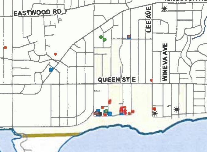
City of Toronto / GENIVAR · Figure 2.2 · Map dated March 10, 2010.
See the local sewers and surface-flow routes
The City’s 2012 study map shows storm, sanitary and combined sewers, surface-flow routes, low points and the Kenilworth tank. The blue arrows show flow over the ground.
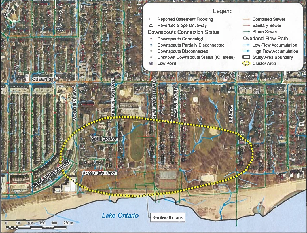
City of Toronto / GENIVAR · 2012 study · Original map · PDF p. 175 · Enlarge map
For catchbasins and planned changes, see the Waverley proposal drawing (p. 314) and Kewbeach proposal drawing (p. 321). These distinguish existing pipes from proposed work.
Causes of basement flooding
Surface water, sewer backup and leaks can all bring water into a basement.

Read the flooding pathways
- Street water enters the sewer. Ponding can enter through a sanitary manhole cover. This is separate from the street catchbasin feeding the storm sewer.
- Sewage backs up into the basement. Overload or a blockage can cause wastewater to return through the house lateral and rise through floor drains or other low fixtures—the brown layer across the basement floor. City explanation · p. 272.
- Damaged pipes add flow. Water can leak between deteriorated storm and sanitary laterals through the surrounding ground; cracks and joints can also admit groundwater. Leakage through soil is different from a pipe cross-connection. Lateral leakage · p. 257; Inflow and infiltration · p. 278.
- Connections vary. Foundation drains may connect to storm or sanitary sewers. Downspouts can add rainwater to underground pipes, including through improper sanitary connections. The original note allows for interconnected systems.
- Water also enters from outside. Poor lot drainage, overflowing eavestroughs, plugged downspouts, reverse-slope driveways, leaky windows or doors, and homes in ponding or overflow paths are all shown. Cracked basement walls provide another route.
The accompanying fact sheet also lists foundation-drain and sump-pump failures.
Bring your concerns to the council candidate meet-and-greet.